|
Article 4 of 6 on Studying the Moon Sailing the Lunar Seas Michael Packer Comments: m·DOT·packer·AT·Yahoo·DOT·com |
|
Most of you know the dark features on the face of
the moon are Atlantic sized lava plains named as seas, oceans, lakes and
marshes. There is a rich history of observers believing or perpetuating that the moon
is made up of continents and seas much like earth. Today we know that these
plains are impact basins filled with basaltic lava. But the mariner names still
remain and many observers are glad they do. As it turns out, “sailing these
lunar seas” is a crafty way to remember the features rising out of these dark
gray waters and recall the names of coastal mountains.
No rules to imagination: Sailing the lunar seas means use whatever you like to imagine to remember the big picture and familiarize yourself with the
entire face of the moon. And you are an expert if you can recall/draw a detailed map of
the full moon, will all its major maria, craters, isthmuses and mountains
without using an atlas.
It is actually pretty easy using the mariner theme.
Early scientists believed the craters dispersed across the maria were volcanic
islands and sunken atolls. Besides theses crater islands, there are buried rims
of large impacts that look like island chains and lone protrusions that look
like islets, large reefs, and even sunken ships. In the case of dorsum, wrinkled ridges of the lava
plain itself, one can readily imagine ocean waves making there way to coastal
shores and bays. I particularly like the word dorsa. It reminds me of the word
dorsal - as in dorsal fin. And I remember some dorsum as turbulent wave crests
from an underlying serpent.
Our port of departure is winding snake sea Mare Anguis within the
northeast side Mare Crisuim. As we leave this winding sea to the western shore of Mare Crisium, look first the barrier reef of dorsa that circumnavitage the entire shores of Crisium: Dorum Oppel, Termier, Harker, and Tetyaev which we cross. And be on the look out for the unamed dorsa that ends in the middle of the sea near Crater Eckert. Givin the curvature of the moon, craters Peirce and Picard should rise above the horizon when their within some 60 kilometers. We we pass between them and traverse the waves of Dorsa Oppel as we arrive at the promontoria, Cape
Olivium and Lavinium.
By the way, good days to set sail are these waters is day 2 or 3 of a waxing
Sailor’s moon. It’s called a sailors moon mostly for the superstition of farer
seas with a new moon. In turn, lunar geographer Riccioli (1651) named the 1st
Quarter maria pleasant names. From north to south these seas are: Sea of
Serenity, Tranquility, Fertility, and Nectar.
Now love can be measured by degrees - yes? If one
sails southward on day 4 and 5 the answer is “Yes” as serenity begets tranquility which begets
fertility which begets nectar. That’s your birds and bees sailing tip for the
day except that if you go too far south into Nectar (perhaps you heard a siren's call) you end up in the semi open
crater Fracastorius. Fracastorius could be a named bay. Unfortunately it is not
and if you entered it, you’ve run aground. Fortunately, Fracastorius was once a
doctor and a poet. In fact the word syphilis is derived from Fracastoro's 1530
epic poem.
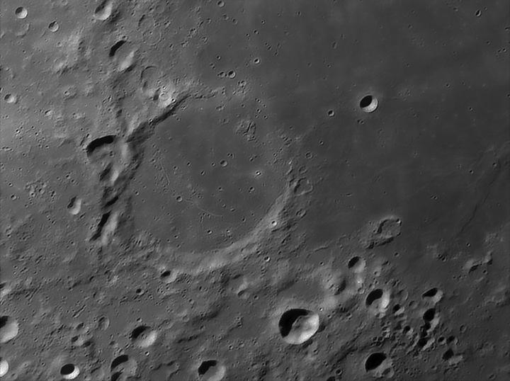
Crater Fracastorius on the
South Bank of Nectar
Anyway, with a little treatment you’ll never forget,
you’re on your way north again passing our exit from Crisium, into the sea of
Serenity, and heading westward. We pass Lake of Dreams (Lacus Somniorum) on our
left (north) to Cape Fresnel (Promontorium Fresnel).
Interestingly, there is a prominent dorsa at the
entrance to Mare Imbrium, Sea of Showers giving the impression of a huge wave
and current at this small opening in the isthmus that separates the Apennines
from the Caucasus.
Following the coast north to Cassini, note the 3
large island craters Aristillus, Autolycus and Archimedes to the south along the
Apennines. Learning craters in small groups of 2 and 3 is the way to go on the
moon and these craters that all begin with the letter “A” are an excellent
example.
Probably the best known examples of lone islands in
Mare Imbrium are Pico and Piton. We pass Piton first, before we pass the
coastal Alps with its large valley or river opening. Pico is then seen standing
apart but representing the beginning of an island chain called Teneriffe
Mountains. Under Moderate magnification Pico is a beautiful multi peaked island
and the group as a whole reminds me of the Hawaiian Islands.
Next we pass the Montes Recti. These Right Mountains often remind
me of a sunken gray plastic battleship found in the game “You sunk my
battleship”. If you also a product of this Milton Bradley game - see if you agree.
Sinus Iridum is my
favorite bay. Study it close to the T at about 150x and see if you can spot the distant
waves coming in from Imbrium. And look for the 4 “unnamed ships” anchored
just inside the bay past Cape Laplace.
I think by now you get the idea of how to sail the moon. I leave you to master Mare Frigoris to Mare Cognitum and beyond. Keep a journal of your travels and pick a choice ship like the HMS Resolution. If I have time, I just may write a short story of this lunar adventure myself with plenty more notable nautical features.